


Creating a Greener Environment with Google Maps Platform’s Newest Service
- What Is Google Maps Aerial View API?
- Major Benefits of Aerial View API

- What’s in It for Me?
- Measuring Impact
Google Maps 10.06.2024 


Your Down-to-Earth Guide to the Google Maps Aerial View API
- What Is Google Maps Aerial View API?
- Major Benefits of Aerial View API
- What’s in It for Me?
- Measuring Impact
In May 2023, Google rolled out the Preview build of Google Maps Aerial View API. Using the 3D map source identical to that of Google Earth’s (Where does Google Maps get its data?), the new product aimed to help businesses deliver context-driven, granularly digitized experiences to their customers. To achieve the desired level of immersion, the tech giant brought artificial intelligence (AI) and computer vision (CV) technologies into the mix, building upon its past geospatial successes.
After months of rigorous testing in real-world settings, Aerial View API made its official entrance onto the public stage. In this article, we break down the core concepts, determine the value that your organization can tap into, and examine some of the most widely referenced use cases.
What Is Google Maps Aerial View API?
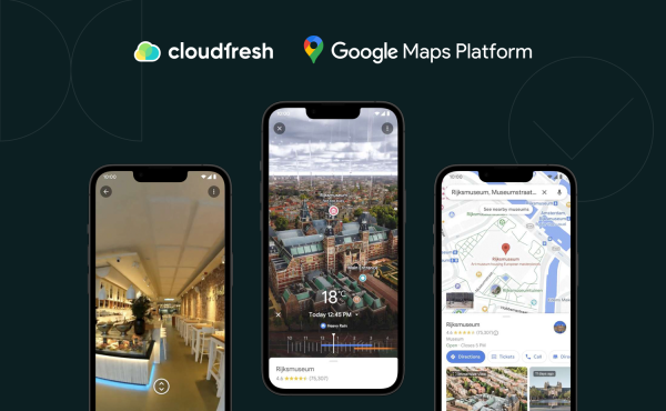
Google Maps Aerial View API is an application programming interface that allows users to submit requests for retrieving photorealistic, drone-simulated footage of physical locations in a three-dimensional space. The ultimate goal is to enable prospective end-consumers to familiarize themselves with the location before finalizing a purchasing decision.

First things first, you need to check if the video has been produced by Google yet. Assuming you already have a Google Cloud instance up and running and API keys issued, you need to post lookupVideoMetadata to check out the state.
- If it returns
ACTIVE, it means that the video has been pre-rendered by Google and already sits in a database waiting for alookupVideoAPI call to be made. - In case a video hasn’t been generated yet (i.e., the response is a
404), you can simply query therenderVideoendpoint.
It is important to note that, at the time of writing, Aerial View API is available to select U.S. postal addresses only, with the rest of the regions being a work in progress.
Major Benefits of Aerial View API
Now that you know what Google Maps Aerial View API is, let us take a closer look at the benefits it has to offer business-wise.
Reduced Expenses
Costs come top of the list. Say you decided to set up and execute an aerial footage project in-house. In order to successfully complete it, you would need to acquire specialized equipment (a quadcopter), hire additional staff (an operator), and purchase relevant software licenses (e.g., Adobe Premiere Pro).
A huge yet often overlooked shortcoming of this approach lies in the fact that equipment tends to break down or malfunction when not used properly, making your upfront investment disappear into thin air. In the case of outsourcing this type of activity, you remove the associated burdens but still have to locate the most cost-efficient and professional contractor or agency. With Google Maps Aerial View API, getting a full-fledged 360-degree bird’s eye view of an area of your interest is as easy (and free) as searching for a video on YouTube.
Faster Time-to-Market
Not having to do things manually will naturally save you time, too. But the implications of that are way more far-reaching. Besides letting your teams focus on key business activities, you also get to hit the market more quickly, potentially outpacing your competition.
In turn, that may help you fill a niche that has only just emerged, win a larger share of an existing market, or come up with completely new offerings altogether. Adding to the personnel point above, with Google Maps Aerial View API, you need no heavy IT involvement for scaling up or down. At the same time, it is the API itself that does all the heavy lifting, i.e., processing, storage, and delivery. All things combined, the potential ROI seems more lucrative than ever — especially in an economy like this.
Ready for lift-off? Just kidding — no drones involved. Reach out, and we’ll cater to all of your display needs (bonus: access to a seven-level discount system across the entire GMP portfolio). I’m interested →
What’s in It for Me?
In this part of the article, we’ll show you how Google Maps Aerial View API plays out across various industries and their key actors.
Real Estate
A 3D aerial view of a property and its neighborhood can be particularly useful for showcasing large estates, highlighting key features like pools or expansive yards. Potential buyers can virtually “fly over” to see nearby bodies of water, parks, forests, educational institutions, hospitals, stores, malls, parking lots, and roadways or even get a feel for traffic patterns.
In a competitive market, real estate listings need to stand out. Using the API creates a more immersive and engaging experience for potential buyers compared to static photos or basic map views. Apartment List, a U.S. rental matchmaker, reports that the number of leads who reach out upon engaging with Google Aerial View is 100% higher than the number of those who are shown apartment unit 3D tours.
Moreover, potential buyers can explore properties remotely, whenever and wherever they want, saving them multiple in-person visits and realtors, valuable time and resources.
Travel
Aerial street views can be integrated with travel planning apps, allowing tourists to visualize their itineraries with immersive aerial views of each address or stop. That way, they can better understand travel distances, spot nearby attractions, and gain insight into factors like noise levels or beach access.
For travelers overwhelmed by the sheer volume of text-based information available online, a quick yet informative aerial video can be a life-changer, encouraging them to book with confidence.
And this goes for both adventure seekers virtually “soaring” over hiking trails or historical sites and relaxation enthusiasts getting a glimpse of serene beaches or peaceful resorts. But most importantly, the Google Maps Aerial View API can be utilized to craft virtual tours of destinations that might be physically inaccessible to some travelers.
Retail
Virtual walkthroughs can come in particularly handy for showcasing unique features like dedicated play areas or rooftop patios. The Google Maps Aerial View API can be integrated with product pages, allowing customers to go over specific departments or product displays and receive wayfinding assistance.
Google estimates that imagery generated in the 3D format yields 50% more engagement than its static analogs, helping retailers bring shopping experiences to an unprecedented level of enrichment.
Like a few other Google Maps services, Aerial View can be also used to create virtual tours that showcase accessibility features, allowing customers with special needs to plan their visits in advance and feel more confident about shopping in person.
Apart from that, new employees can use aerial views to familiarize themselves with the store layout and product placement, potentially reducing training time and improving customer service.
Entertainment
Filmmakers can use aerial views to scout locations virtually, visualize potential shooting angles, and get a feel for the surrounding environment, saving resources compared to traditional methods. In addition, the Google Maps Aerial View API can be used to generate footage for later use in movies, series, or documentaries.
Event planners can use aerial views to showcase event venues to potential clients, which is particularly helpful for outdoor venues, festival grounds, or concert stages. Aerial views can be incorporated into event marketing materials, allowing clients to visualize the layout and attendee flow, among other things.
One such thing is exactly what Rocket Entertainment did when prepping Elton John’s farewell tour. Thanks to breathing life into places where the star was a frequenter with Aerial View, the company enjoyed a 14% growth in subscribers compared to previous brand activation campaigns.
Measuring Impact
Our expert team can implement the following funnel to help you gauge the success of your Aerial View API usage.
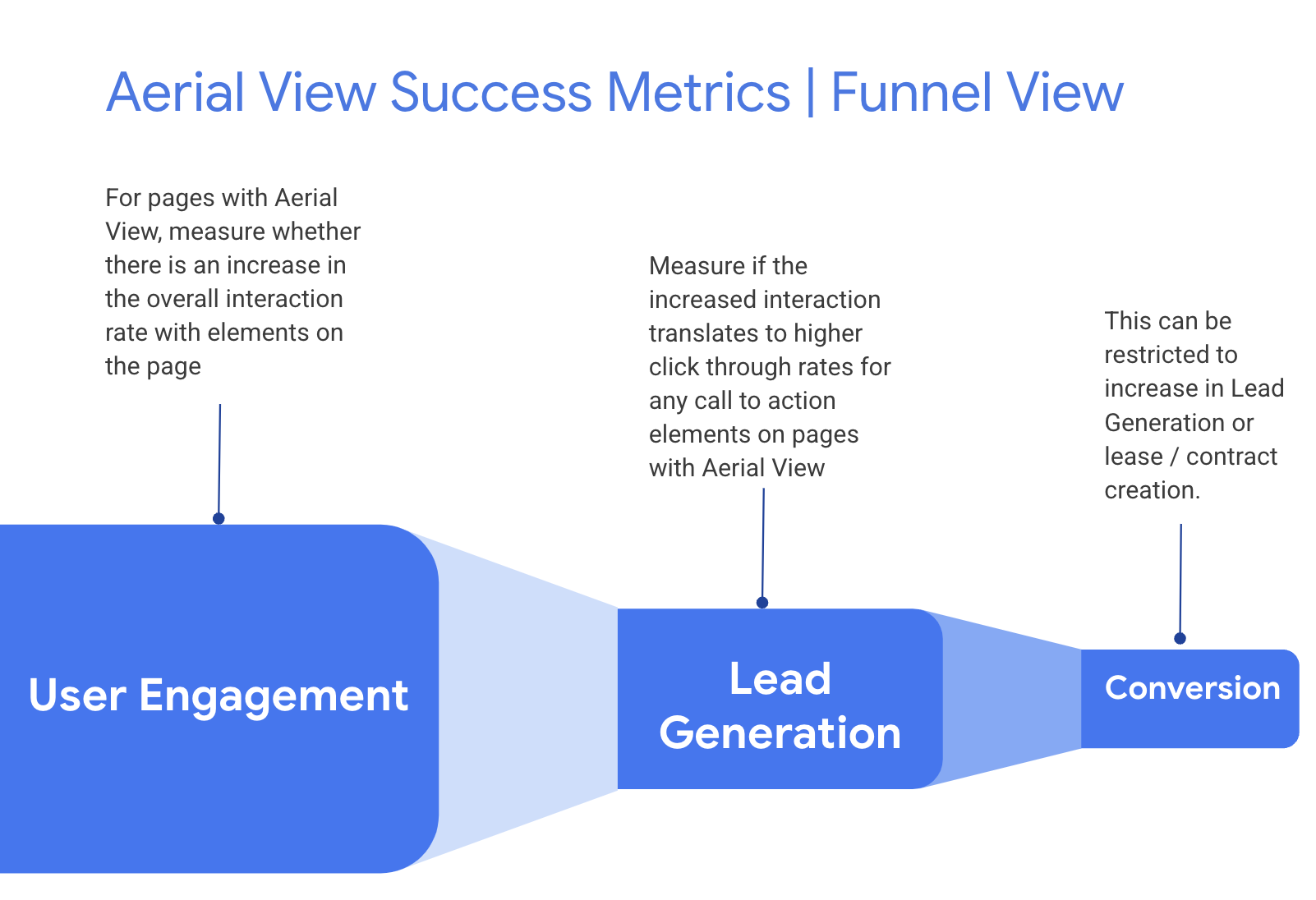
Source: Google
Among upper-funnel metrics to follow, there are:
- The share of users engaging with one or more aerial videos per visit.
- The frequency of clicking/tapping interactive elements.
- The number of reposts and saves.
- The time spent on the page.
- The bounce rate.
As for the lower-funnel metrics, the list is as follows:
- LeadGen rate, or CTR.
- Lead-into-contact conversion rate.
On top of that, our Google Maps Platform team can also assist you with setting up numerous scenarios for A/B (or split) testing so you can pick out relevant hypotheses and identify test groups.
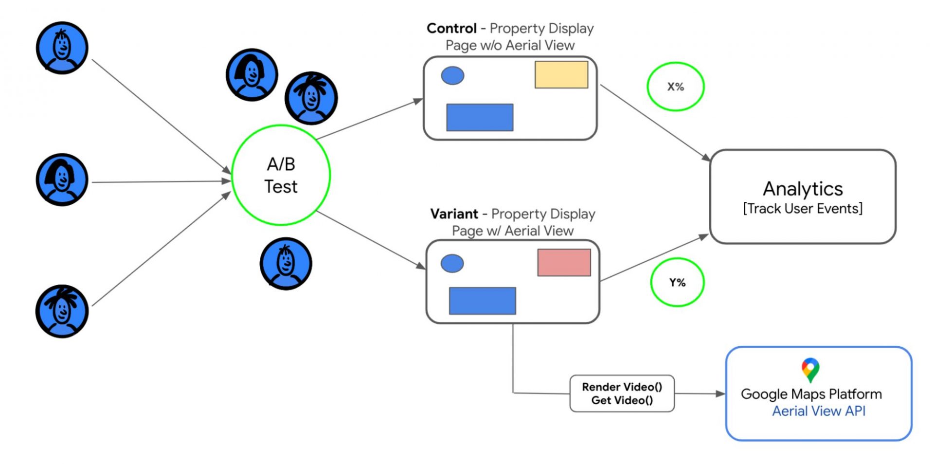
Source: Google
Not sure how to use Google Maps API (Aerial View included) for your business? As a certified Global Google Cloud Premier Partner, Cloudfresh can help. Submit the form below and get a free strategy session to see what you’ve been missing.

Get in touch with Сloudfresh